FastStats release notes 2023
Our FastStats development team works using quarterly releases. Scroll down to see the FastStats quarterly releases from this year.
Note: Since the Q2 2023 release, Apteco desktop software requires a minimum of the .NET Framework 4.7.2 or later to be installed.
Note: Please see Notes for administrators for steps to be completed before applying a quarterly upgrade to your Apteco software.
FastStats Q4 2023 software release
New features
Analysis
New penetration mapping capability
Penetration mapping compares particular groups of customers by location.
This new functionality builds upon the capabilities of the modelling Profile tool, which allows you to find categories and characteristics of interest or over/under-representation within an analysis group and compare them to a wider base group. Now you can work in a similar way to search for and visualise geographical insight in your data using the Map tool.
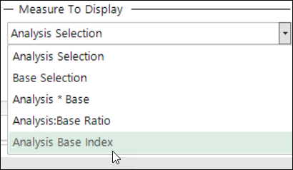
The new Selections option, accessed via the mapping toolbar, is where you add your analysis selection and choose to compare it against, either your entire base, or optionally a specified base selection. You can select the insight measure to display and present the results very visually on a map.
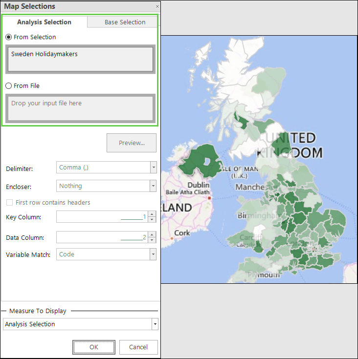
The calculated metrics include:
As well as being able to compare two groups of people within your FastStats data - for example, your Sweden customers vs. all your customers - it is also possible to take records within your FastStats system and compare them against an outside population. For example, you might wish to compare the location of your own customer base against the actual population count in each postal area to find what percentage of the people in each area are already your customers. You can achieve this by using a lookup file that has one row for each postal area and contains the relevant geo-demographic information.
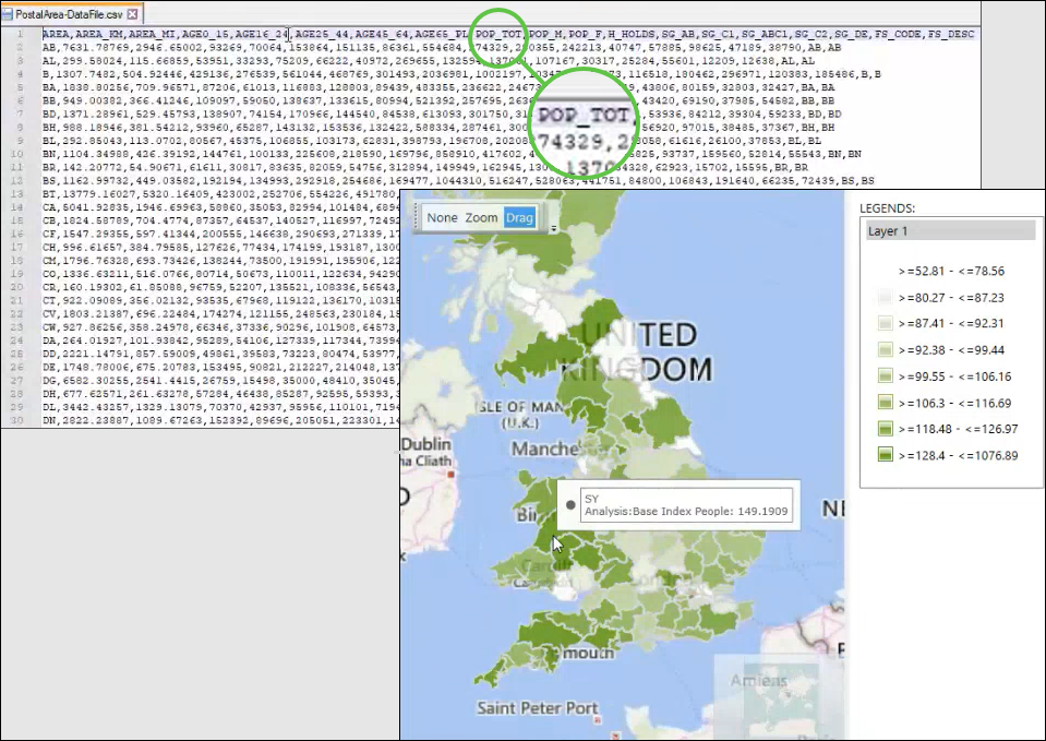
See Bing Maps: Penetration Mapping.
N% per variable sampling in selections
N per table (such as 1 per household) and N per variable (such as 1 per email) functionality has been available in FastStats for many years, but is now extended to provide a much simpler solution to a common sampling requirement - that is, to sample N% of records whilst maintaining the distribution across the underlying variable. For example:

On the left is a selection of 108,876 Directors, Managers and Professionals, broken down in a cube by Income Groups. On the right you can see the effect of sampling 10% per Income Group. The % Column of People metric shows that, with the new N% per variable functionality, the distribution across the Income Groupings variable remains constant.
Rather than looking for the percentage of records across the variable, you can also take the alternative approach of determining the total number of records you require:
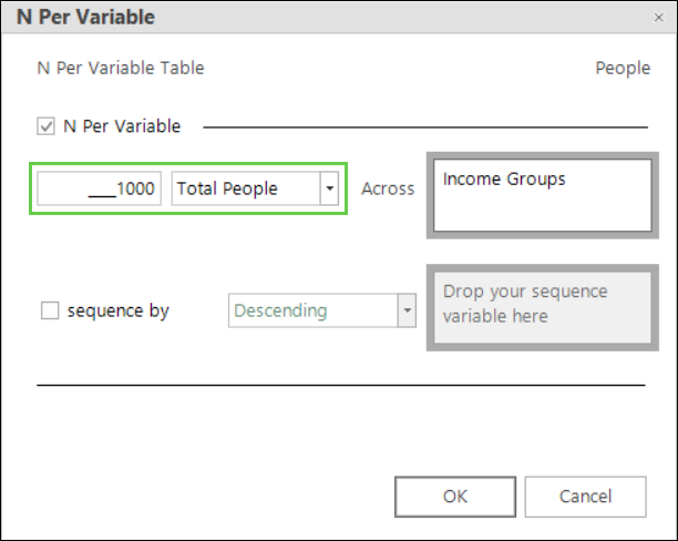
The resulting cube shows the count and corresponding distribution of records based on a target sample of 1000 people.

See Selection: How do I make a N% per variable selection?
Cube, tree and word cloud conversions to map
For a cube, tree or word cloud which has a single geographic variable, such as Postal Area, you can right drag and convert into a map. The variable must be a selector and have the GeoFormat property set for this to be possible.
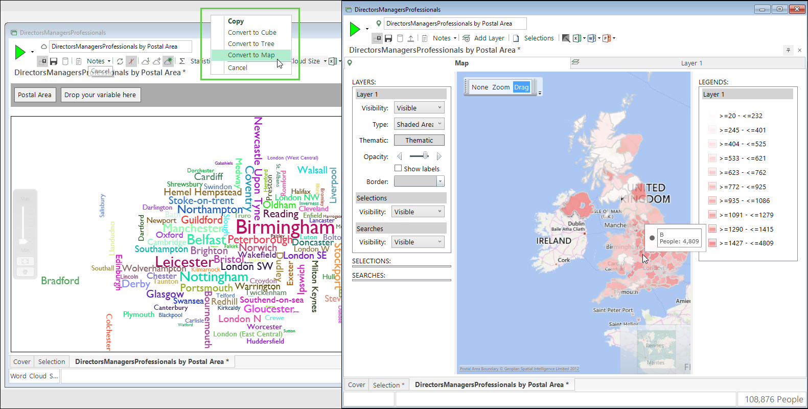
See How do I switch between cube-based visualisations?
Change to Map drivetime dialogue
When creating drivetime analysis, you now have two choices for selecting the origin of the drivetime - either the point you clicked, or the point you searched for. This can help to produce more accurate drivetimes, particularly when supplying the Bing Isochrone API with a centrepoint that is not near any roads.
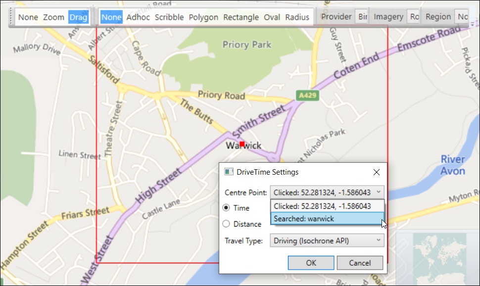
See Bing Maps: drivetime calculations
Extension to Relative Transaction on the fly aggregation
The ability to include a third piece of transactional information was introduced for Rank, Recency and Pattern Match aggregations in the Q3 release. This is now extended to include Relative Transaction aggregations and, like Recency, allows you to specify two ordering variables and use the second one to break ties when the first one is equal.
See Aggregations on the fly - Relative Transaction
Expressions
Four new expression functions have been added:
-
InListAllMatches and IndexFromList - these new logical functions allow for all matches to be returned rather than just the first match found.
-
DateToNumber and DateTimeToNumber - allow you to convert a date or datetime into a numeric value.
General
-
We’ve implemented a FastStats Service fix to prevent passwords from being exposed in the Configurator. For more information on this fix, see Prevent passwords from being exposed in the Configurator.
Bug fixes
| Area | Description |
|---|---|
| Expressions | Fixed an issue where not all expressions have pop-up quick help. |
| Fixed a bug with Index functions where the return value is an If/Case function. | |
| Implemented better validation of properties for UKPostcode and UKPostcodeFormat. | |
| Fixed issue of reporting valid date parameters when not valid. | |
| Fixed issue of MinIndex and MaxIndex functions not validating that their parameters are all of the same type. | |
| Fixed an issue that prevents the Index function from parsing if it is the first returned parameter. | |
| Virtual Variables | Fixed an issue where the wrong data type is presented in the wizard when editing a currency virtual variable. |
| Fixed an issue where the wrong icon is displayed for currency and datetime virtual variables in the Manage Virtual Variables screen. | |
| Scheduled Task | Fixed issues of clipping in the Manage Scheduled Tasks UI - with the Private Key and at the bottom when using the scrollbar. |
FastStats Q3 2023 software release
New features
Analysis
Powerful extension to on the fly aggregation capabilities
For the ranking, recency and pattern match techniques, the on the fly aggregation processing mechanism is extended to provide the option of including a third piece of transactional information.
-
Rank Transaction allows you to use a second grouping variable to create ranking aggregations.
-
Recency allows for a second ordering variable which lets you break ties when the values of the first ordering variable are equal.
-
Pattern match allows you to specify a grouping variable, with transactions split into these groups before the pattern match algorithm is applied to each group individually.
Custom colours in cube, tree and map thematics
In addition to all existing thematic options, you can now user define and set a custom sequence of colours for the bands displayed in a cube, tree or map. This is useful for presenting insight when the graduation of colour is not significant, but differentiating information in the display is beneficial. For example, to clearly indicate in a cube that, for average cost, <X is bad, X-Y is ok, and >Y is good, you might opt to colour the corresponding cells red, yellow and green:
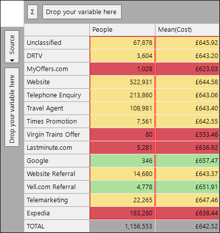
You can similarly display records in a map or, alternatively, as demonstrated below, you may wish to assign colours to map shapes based on discrete values. The following visualisation displays a parliamentary map coloured to highlight the winning political party for each area:
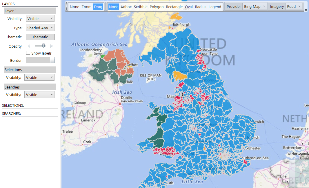
See Custom Colours in Cube, Tree and Map Thematics.
Custom labels in map thematics
The introduction of custom colours on a map also brings the ability to set up corresponding custom labels for each of the bands in your thematic shading. These labels are visible in the map legend and help to provide further meaning to user defined colours.
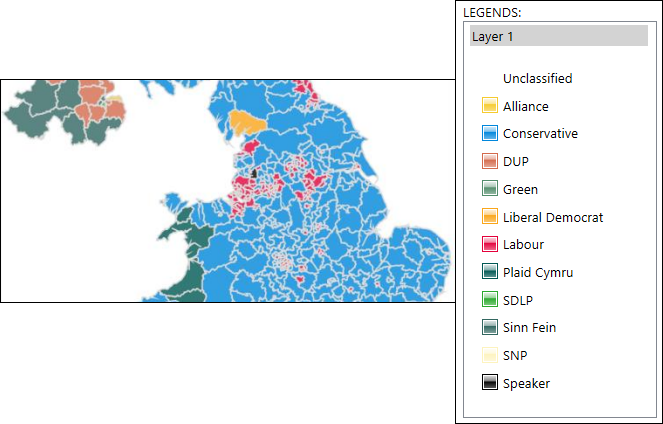
See Bing Maps Shaded Map - Custom Thematic Labels.
Expressions
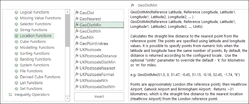
New context sensitive help in the expression window provides an explanation and worked example for each function.
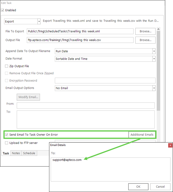
Scheduled task error notification
In addition to notifying the task owner, you can now specify a list of additional email addresses to which a notification should be sent if a scheduled task errors.
General
Bing transaction logging
Bing transactions are now recorded and stored in CSV files, allowing administrators to easily:
-
Track and verify usage
-
Provide clarity on transaction counts and allowances
For more information, see the Bing transaction logging technical update.
Apteco FastStats bug fixes
| Feature | Description |
|---|---|
| Map | Fixed an issue of thematic/plot map saved with no underlying map not reloading. |
| Fixed an issue of incorrect highlighting in thematic map with 2-way measures. | |
| Fixed an issue of incorrect legend with 2-way measures. | |
| Fixed an issue of map legend having infinity symbol in ranges. | |
| Fixed an issue of Routes alternative being offered when the Public Transport Bing API endpoint times out. | |
| Fixed an issue so that the user is informed when public transport from map drivetimes time out. | |
| Fixed an issue where thematic maps with 2-way measures save but load back incorrectly. | |
| Expressions | Fixed an issue where, in some circumstances, StrFind function fails on Ansi systems but not UTF8. |
| Fixed a crash issue with pattern match aggregations ordered by a non-integer numeric, returning start/nth/end order value. | |
| Fixed an issue where the ‘Allow Pattern Overlaps’ checkbox is always visible when editing a pattern match aggregation. | |
| Fixed an inconsistency with the MaxCategoryAggregation returning the second last category. | |
| Wizards | Fixed an issue with the Territories wizard where existing variable case has unnecessary entries in the dropdown list. |
| Fixed an issue of not being able to edit virtual variables created using the Calculate Expression wizard when the expression is not a numeric. | |
| Fixed a crash issue for the Point to Point wizard with a 2-column centrepoint file. | |
| Fixed an issue where selections with transforms are not allowed in virtual variables. | |
| Fixed an issue so that the maximum value panel for the Point to Point wizard geographical variable case has a context menu for selecting variables. | |
| Fixed an issue in the Point to Point wizard where the user could move on from the Maximum value step without setting the latitude and longitude variables. | |
| Data Grid | Fixed an issue where the folder does not refresh for a data grid exported as a CSV file into the Files explorer. |
| Security | Fixed a security concern related to Chromium in FastStats. To mitigate the security flaw (CVE-2023-4863) in the WebP library, we have updated Chromium to version 116.0.230 within FastStats. See WebP library security flaw in Apteco FastStats. |
FastStats Q2 2023 software release
New features
Modelling
New Incremental Insight measure
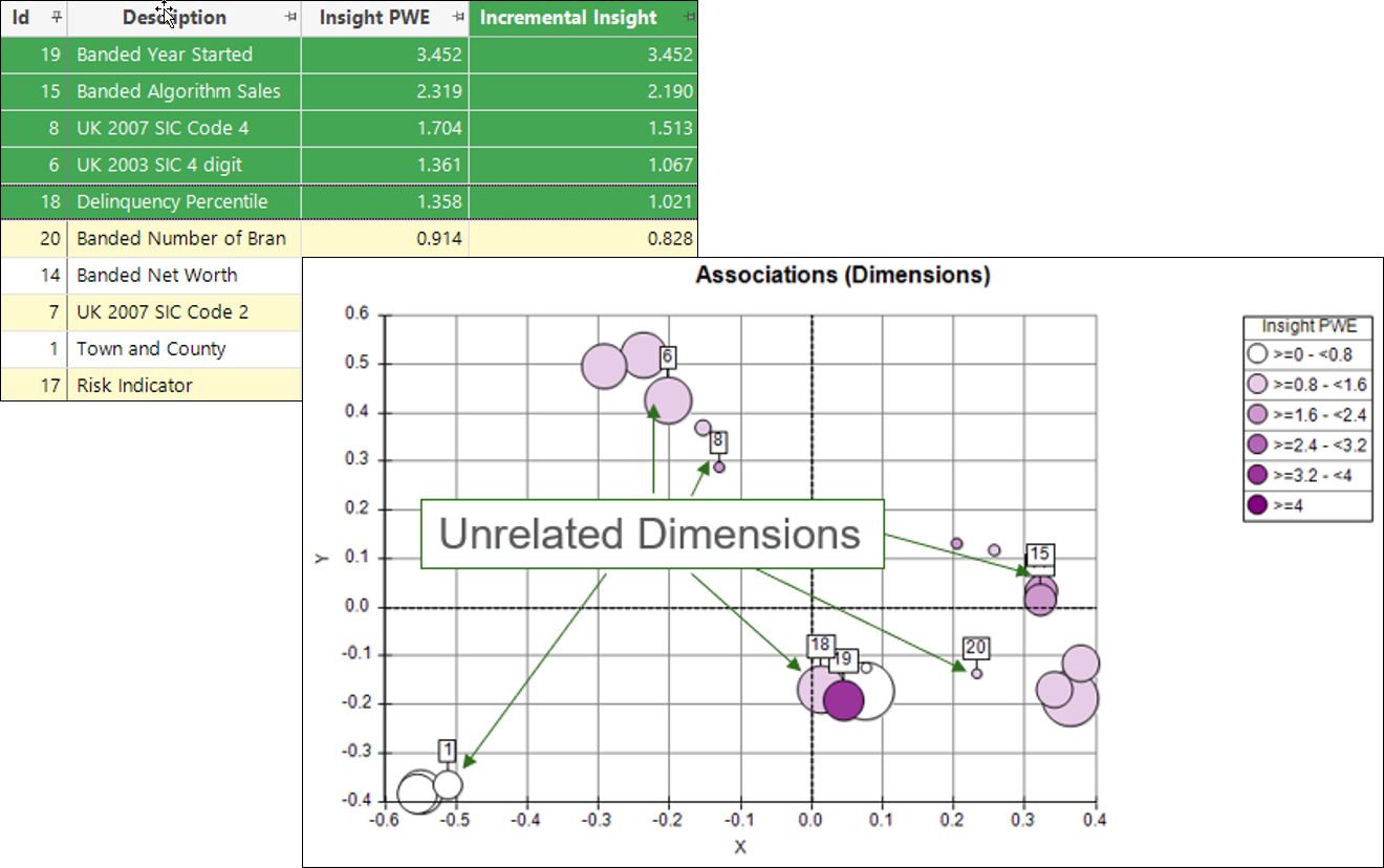
Your ability to identify the best behavioural features to use in a model is extended with the introduction of a new Incremental Insight metric. This single measure allows you to choose dimensions which are both predictive and diverse. It is based on the existing Insight PWE measure, but accounts for the associations between different dimensions. When building the dimension results, there is an additional option which allows for incremental insight to be calculated:
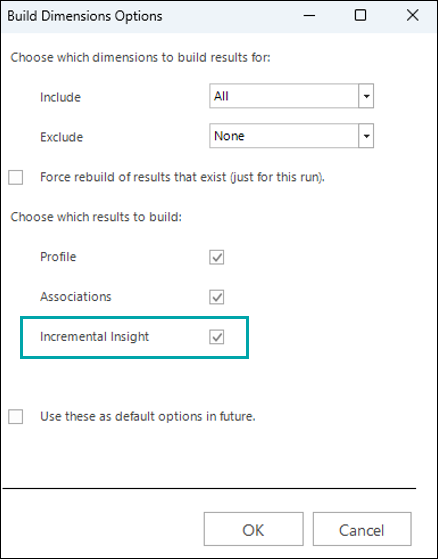
Selecting the top dimensions based on Incremental Insight results in a broader range of variables which would not otherwise be chosen. Shown graphically, you can see that, whilst the top dimensions may be individually lower in Insight PWE, collectively they provide more diverse insight and can produce a model which captures more aspects of a good prospect:
See Incremental Insight.
Bubble chart visualisation
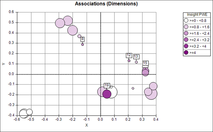
When you select to colour by Insight PWE in the Chart options dialog, scatter charts now display as bubbles to show both the Insight PWE using colour, and the Insight Coverage using size:
See Chart Options.
Insight PWE metric available in standard Profile
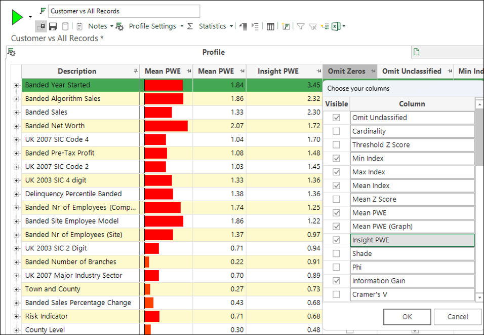
You can optionally add and display the Insight PWE metric as a column in a standard profile.
See Standard Modelling Development Update Q2 2023.
Analysis
Territories wizard improvement
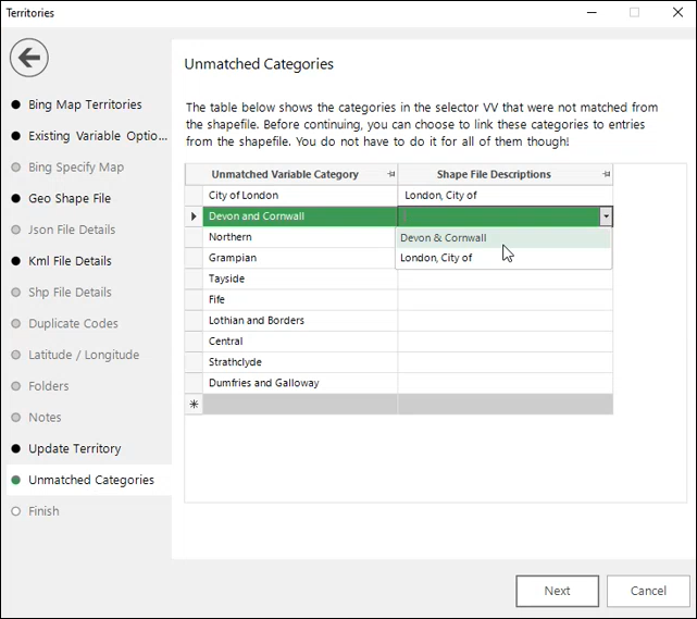
When working with the option to link a new shapefile to an existing selector variable, FastStats now automatically checks for categories in the variable which do not match those in the shapefile. Once identified, you have the opportunity to update them as part of the wizard process.
See Territories wizard.
Mapping usability improvements
The following usability improvements allow you to create maps more easily:
-
You can now drag variables directly on to the Statistics panel on a map layer, rather than having to use the Add Statistics button.
-
Changing the primary statistic on a thematic map layer automatically updates the thematic shading without the need to rebuild the map.
-
On a thematic map layer, you can now right click on the Geographic Variable drop-box to easily access, select and add any available selector variables with a 'GeoFormat' property set.
-
On a plot map layer, you can now right click on the Geographic Variable drop-box to easily access, select and add any selector or text variables with a 'GeoFormat' property set.
-
In Map wizards, where you need to specify latitude and longitude variables, you can now right click and access a menu option that allows you to select and add variables which are marked with the relevant 'GeoFormat' property.
-
When using the Location Geocoder wizard, you can now select a check-box to confirm that your geographic variable is a UK postocode. This allows the virtual variable to be generated using the UKPostcode expression rather than using Bing Geocode. The results are returned significantly faster and without incurring Bing transaction costs.
Bing API caching
Bing API Isochrone: Drive zones created using the mapping wizards are now stored. This means that, when editing the variable, you do not incur new Bing API transactions for zones that have previously been calculated.
You can configure zones to have an expiry period after which they are then recalculated.
BIng API geocoding: Searching for locations on an interactive map, or through specifying centrepoints in the Map wizards, incurs Bing API geocoding transactions. From Q2 2023, specifying a centrepoint in 'Latitude.Longitude' format (for example, 52.281806,-1.588657) is treated as valid location information. This is a user-configurable property.
If you have to request a geocoded location from the Bing API, the resulting latitude and longitude is stored and can be reused if you request it again. This is supported in the interactive map search and the map wizards’ Centrepoint step.
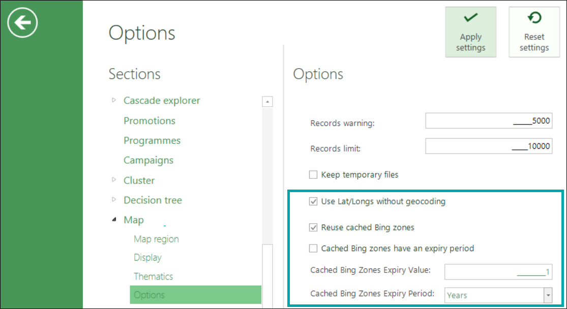
See Bing API.
Import Data wizard enhancement
When creating a selector type variable from a data file, previously both the codes and descriptions for the resulting variable were taken from the data column and were the same. You can now specify a second column in the data file and use this to generate the category descriptions for the resulting variable.
See Import Data Wizard.
Expressions
New and updated expression functions
There have been updates to existing, as well as the addition of new expression functions, including:
-
Selector functions: VarSelectNth and VarSelectCodeNth
-
DateTime list functions: FirstDateTime, LastDateTime and NthDateTime
Security
Transition from SHA-1 hashing algorithm for enhanced security
Note: Due to the deprecation of the SHA-1 Security Hash Method, Apteco strongly recommends transitioning to a more secure option, such as SHA-256.
If your FastStats system is currently set to the SHA-1 hash function, then you must upgrade to a preferred hash method promptly. This upgrade ensures that you are using the most secure hashing method and avoid any security issues for using a deprecated service.
See Change hashing algorithm for FastStats systems.
Apteco FastStats bug fixes
| Feature | Description |
|---|---|
| Wizards | Drive Zone wizard: Fixed an issue where the Next button was not disabled whilst the Bing API Isochrone request was processing. |
| Drive Zone wizard: Fixed issue of multiple requests processing causing crash. | |
| Territories: Fixed an issue of unusable KML file. | |
| Territories: Fixed an issue of unnecessary pages displaying when linking to an existing variable. | |
| Fixed an issue where World.json file could not be used to map against Destination as some features were null or missing. | |
| Modelling | Fixed an Issue of PWE/Decision Tree virtual variable with expression not being usable in an analysis or base selection. |
| Expressions | Fixed and patched an issue where expression columns aggregated on data grids did not return results. |
| Fixed an issue where VarSelectCode did not work with flag array variables. | |
| Fixed an issue where a FirstDateTime function with all missing parameters returned an incorrect result. |
FastStats Q1 2023 software release
New Features
Modelling
Generate multiple behavioural features with different criteria
The selection of behavioural features has the greatest impact upon the final quality of a data model. Whilst recent development has focussed on charts and metrics which help you to assess existing features in order to identify subsets which might be predictive or diverse, this release makes it easier to generate alternative behavioural features. This includes the ability to generate multiple behavioural features with different criteria; simple, combination, or modifying multiple existing dimensions. The new features are generated using one or more existing features as a template. Each new feature mirrors an existing one and adds one additional criterion.
See Generating multiple Behavioural Features with different Criteria.
Use of cube tool to analyse complex customer journey selections
Complex customer journey selections can be generated directly from the analysis you carry out using the FastStats Modelling Environment, providing the flexibility to adjust the analysis date in the selection and easily study different ranges of transaction history.

You can now drag and drop a FastStats Cube onto these selections and carry out further, powerful analysis on the events within a customer journey.
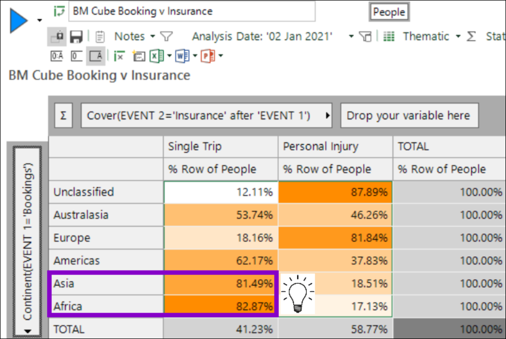
See Using a Cube to analyse a customer journey selection.
Other developments include:
More flexible control of building dimensions
-
Simpler user workflow with the "Use" status
-
The ability to thematically colour multi-dimension charts by Insight PWE
-
Updates to the right-click menu options
-
Edit Details option available in standard modelling
-
Chart and Build options are saved with the Modelling Environment
See Modelling Development Updates for more information.
Analysis
New options for referencing a file of values to use in a selection
The existing ability to import and reference a file of values (for example text or URN) has been extended in this release, with support added for selector and numeric variables.
-
For selector variables there is a new option to reference the codes in the file at the time a selection is actually run. This is in addition to the pre-existing import option which takes the current values in a reference file and matches those current values to the relevant codes in order to select them.
-
Numeric variables are supported as a set of ranges. Any updates to the reference file are also reflected when the selection is rebuilt.
See Selection: How do I import values by reference?
Map wizards improvements
Drive Zone
When creating drive zones for multiple centrepoints using latitude and longitude, you now have an additional option to create a single multi-response (flag array) virtual variable for all points.
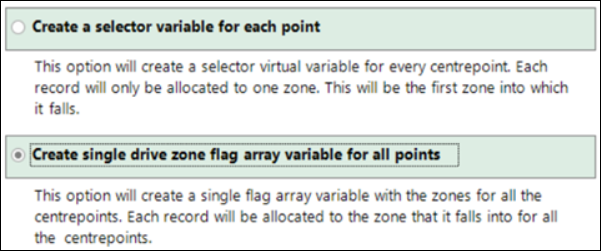
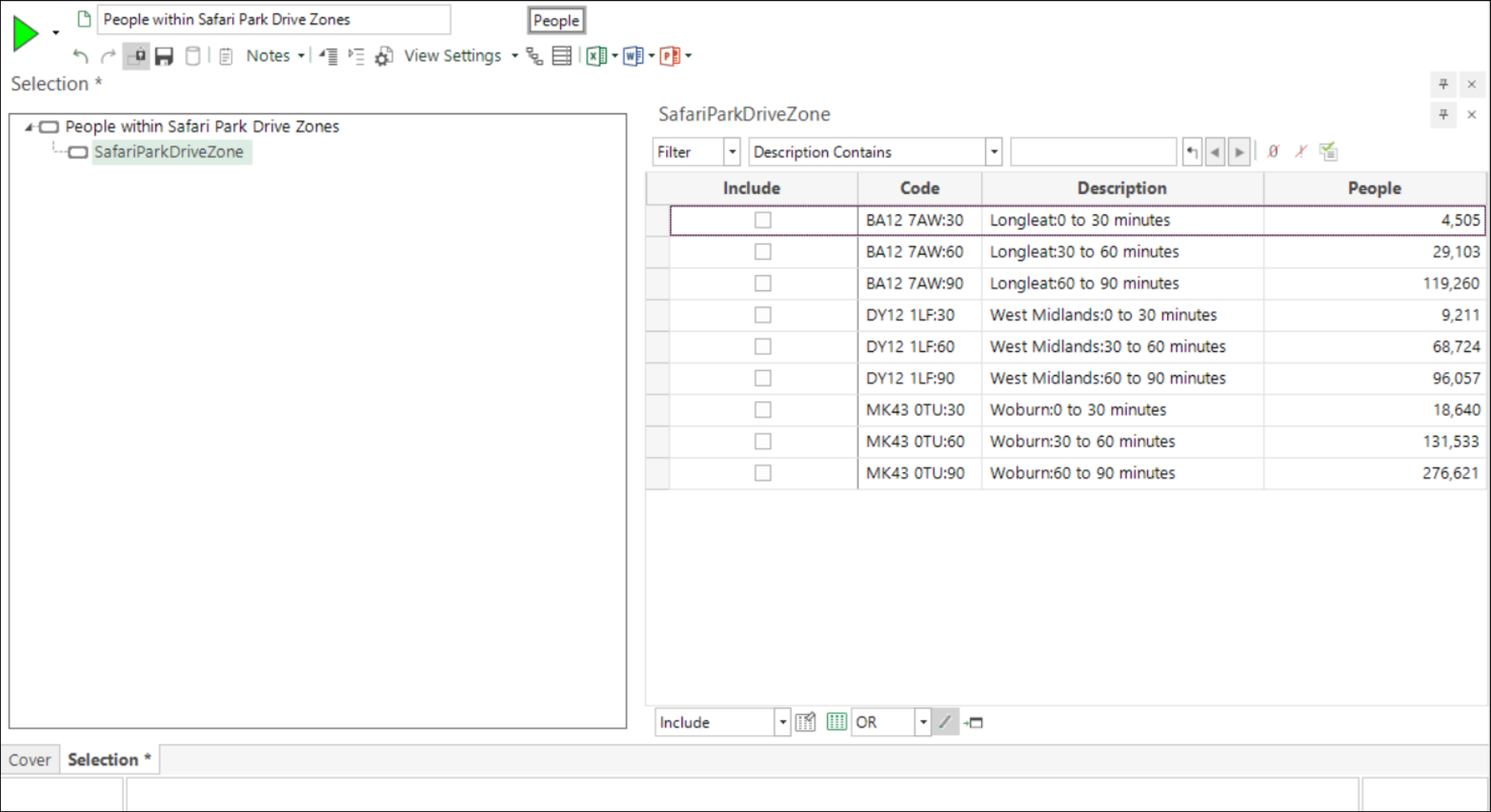
You can use this variable to quickly and easily create thematically shaded drive zone visualisations using the Map tool.
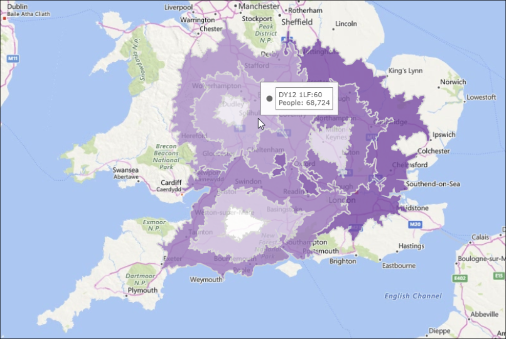
See Drive Zone Wizard.
Territories
It is now possible to see a sample of a selected shapefile’s features and related values, allowing you to easily select a field to be used for the resulting virtual variable categories.
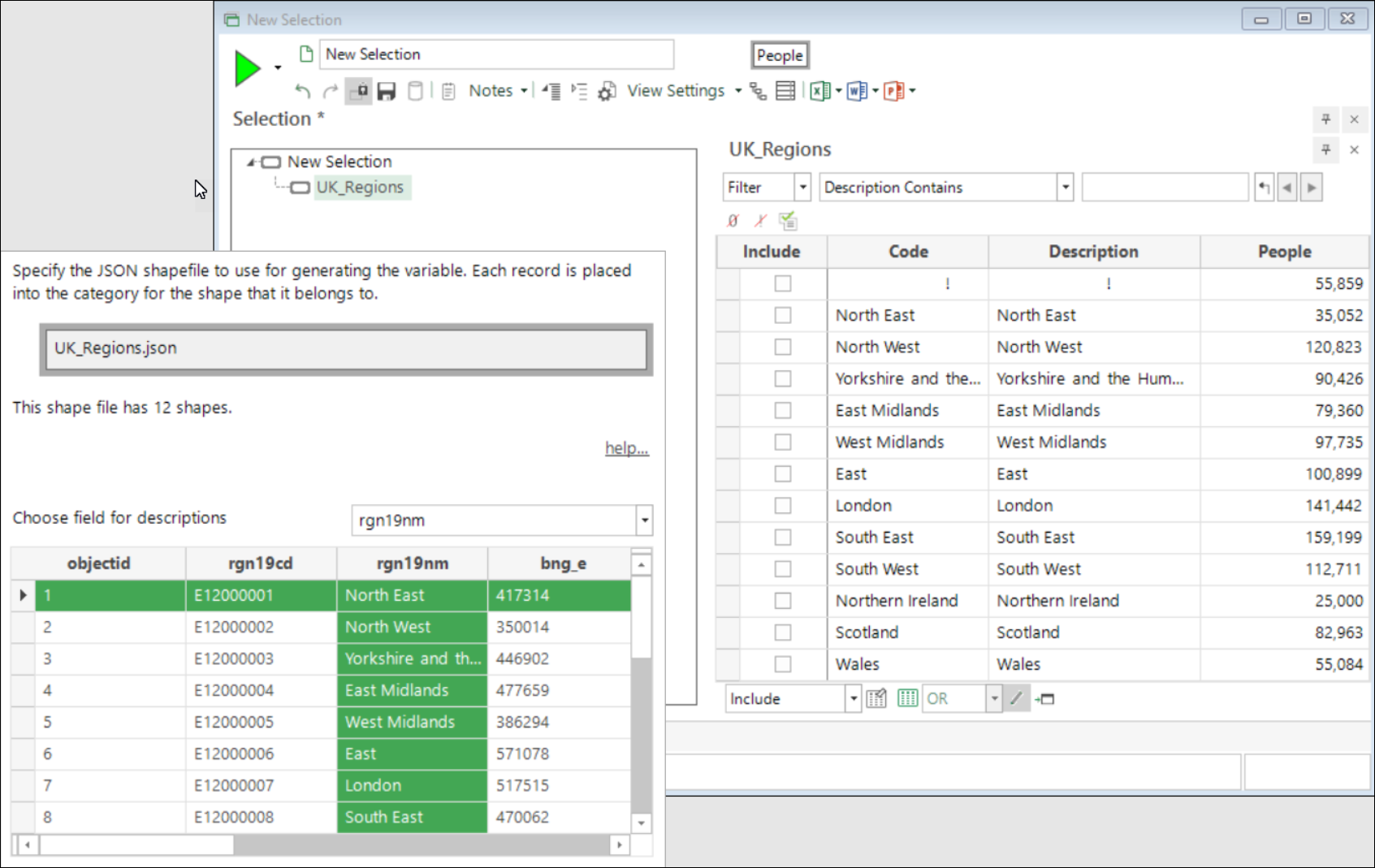
See Territories Wizard: Json File Details.
Removal of Microsoft MapPoint
In the Q4 22 release notes we announced that support of MapPoint would cease from Q1 23. As a result:
-
The Settings page in the Drive Zone and Point to Point wizards has been removed
-
It is no longer possible to select Map Regions in the FastStats Tools-Options
-
You can no longer select to use Routes API as a drivetime option in the Map tool
Expressions
New option to set GeoFormat via Calculate Expression wizard
Recent developments in the mapping wizards often require the use of latitude and longitude variables. Where such variables are not already present in your system data, you can use the UKPostcode expression function to turn a postcode into a latitude or longitude reference. In such cases, the Choose Data Type step of the Calculate Expression wizard now also allows you to set the GeoFormat on these virtual variables so that you can then use them in the mapping wizards.
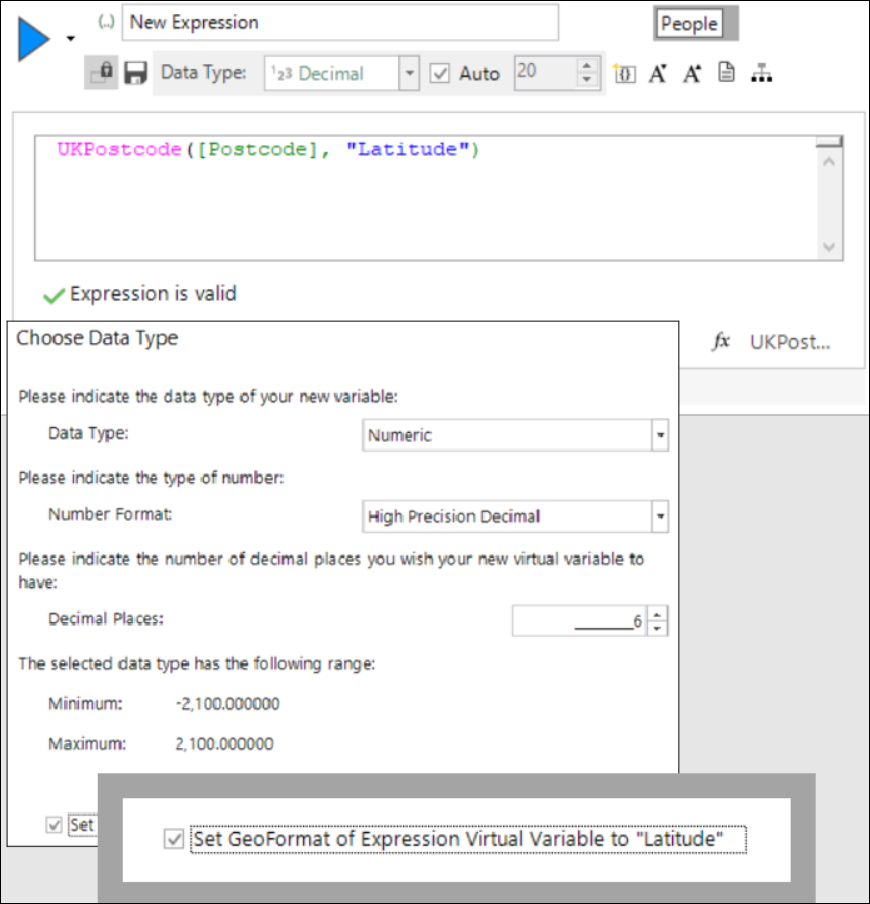
See Calculate Expression Wizard.
New and updated expression functions
There have been updates to existing, as well as the addition of new expression functions, including:
-
NthDate: a new date list function to return the Nth date in a list of dates.
-
NthDistinct and NthDistinctIndex: two new sorting functions which work with numbers, dates or datetimes to sort into ascending order and select the Nth distinct or Nth distinct index parameter respectively.
FastStats bug fixes
| Feature | Description |
|---|---|
| Wizards | Fixed an issue where variables created using the Territories wizard cannot have \ in their names. |
| Rework of Drive Zone wizard to change existing Geo to use Bing Isochrone API. | |
| Fixed an issue of Bing API incorrect warning for number of chargeable requests when using Routes API. | |
| Removed Routes API option from interactive map drivetime and message if revert to it from Bing Isochrone API. | |
| Expressions | Fixed an Issue of dynamic virtual variable expressions being converted to lowercase in memory if there is more than one clause. |
| Fixed an issue where MakeDate and MakeDateTime expressions in the WCP can cause numeric overflow. | |
| Fixed an issue where an on-the-fly aggregation saved as MaxCategory comes back as Category Grouping when reloading. | |
| Map | Fixed Map layer exception when changing between plot and thematic map. |
| Data Grid | Fixed an issue where a Data Grid save from cover fails to save edits made in the data grid. |
| Variables | Fixed an issue where current date is sometimes incorrect in particular queries. |